Haslem's Creek Cemetery (or the Rookwood Necropolis) was opened for burials in January 1867. Initially comprising 200 acres, it was substantially extended, both to the east and to the south, in the 1880s, with an additional 550 acres.

[The original cast-iron Marker Post, facing Necropolis Circuit.]
The original Methodist (or Wesleyan) portion occupied the middle part of the western half, sandwiched between the Old Catholic and the Old Presbyterian portions, and extending from the western boundary to the ring road around the original Mortuary Receiving Station.
Indeed, the road into the cemetery from the western entry (Necropolis Drive) proceeds in a serpentine fashion to the mortuary circle, and forms the actual boundary with the Catholic portion to the north; and the exit road from the mortuary circle back to the western exit (Cohen Avenue) proceeds in reverse serpentine fashion, and forms the boundary with the Presbyterian portion to the south.
All the original roads were laid out in a non-linear fashion - with the single exception of the boundary between the Old Catholic and Old Anglican portions, which ran in a straight line for over half it's length, due north from the centre of the mortuary circle towards the main western Railway line - it is now known as Williams Drive.

[Plan of proposed section layouts, Haslem's Creek Cemetery, August 1868 - courtesy of State Records N.S.W., Ref CGS 8210, and reproduced by the Society of Australian Genealogists, Sydney in their guide to the Transcriptions they made of all visible gravestones during the 1980s.]
The hour-glass shape of the Old Methodist portion either led to, or had been the result of, an internal Section plan that comprised a number of circles. These appear, numbered from east to west, as:
i. two adjacent circles near the mortuary circle, numbered 1A (north side) and 1D (south side), with a single row of inward facing "perimeter" plots between both of these two circles and the boundary roads, numbered 1B (north) and 1C (south).
ii. a larger single circle containing Sections 2A (north-eastern quadrant) and 2B (south-western quadrant), separated by a serpentine "infill" run of Section 2C which numbers on from lower 2C plot numbers in the outer triangle to the north between 1A and 2A, with Section 2D being the northern triangle between 1D and 2B/C.
iii. then another large circle to the west containing sections 3A and part of 3B, with Section 3B continuing into the outer triangles and perimeter rows on both sides.
iv. finally ending in two smaller circles numbered 4A and 4B, balancing 1A and 1D, on the western edge of the portion.

[An enlargement of the Old Methodist Portion of the 1868 State Records Plan, adapted by Graham LEWIS for the Society of Australian Genealogists (S.A.G.), and subject of their copyright, Sydney, 2002. Image downloaded from the Society's C.D.-Rom version of their 1980's transcription of all standing headstones, and used here with their permission.]

[An enlargement of the Old Methodist Portion of the 1868 State Records Plan, adapted by Graham LEWIS for the Society of Australian Genealogists (S.A.G.), and subject of their copyright, Sydney, 2002. Image downloaded from the Society's C.D.-Rom version of their 1980's transcription of all standing headstones, and used here with their permission.]

[I have made some additional annotations, with colour coding for my convenience.]
The current cemetery "plan" issued by the Cemetery Office (see below) is quite vague about the exact locations of section boundaries within each of the larger circles.
Indeed, over the last two years or so, I have tried to locate plots in Sections 2A, 2B and 2C, for the purpose of fulfilling gravestone requests, and also empty plots, for memorials on the www.findagrave.com web-site - and failed.
The result of this failure is that I have now photographed most of the standing and fallen stones with readable inscriptions, and created a map of the large circle comprising Sections 2A, 2B and 2C.It rather looks like when it was originally laid out, it contained only 2A and 2B, and that these were separated by a serpentine pathway that ran west from the south east quarter point, curved to the north through the centre, and then curved back to the west to the north-west quarter point.
And that some time shortly after, or perhaps when the whole section was filling up, that the management decided to infill the pathway with extra plots.
The arrangement, as shown in the attached plan, reveals why it had been so hard to find individual plot locations:

[The Old Methodist Section plan in current use on the Rookwood Cemetery web-site,
showing less than clear Section layouts, particularly in the Section 2 Circle.]
____________________________________________________________________________
CLERGY SECTION.

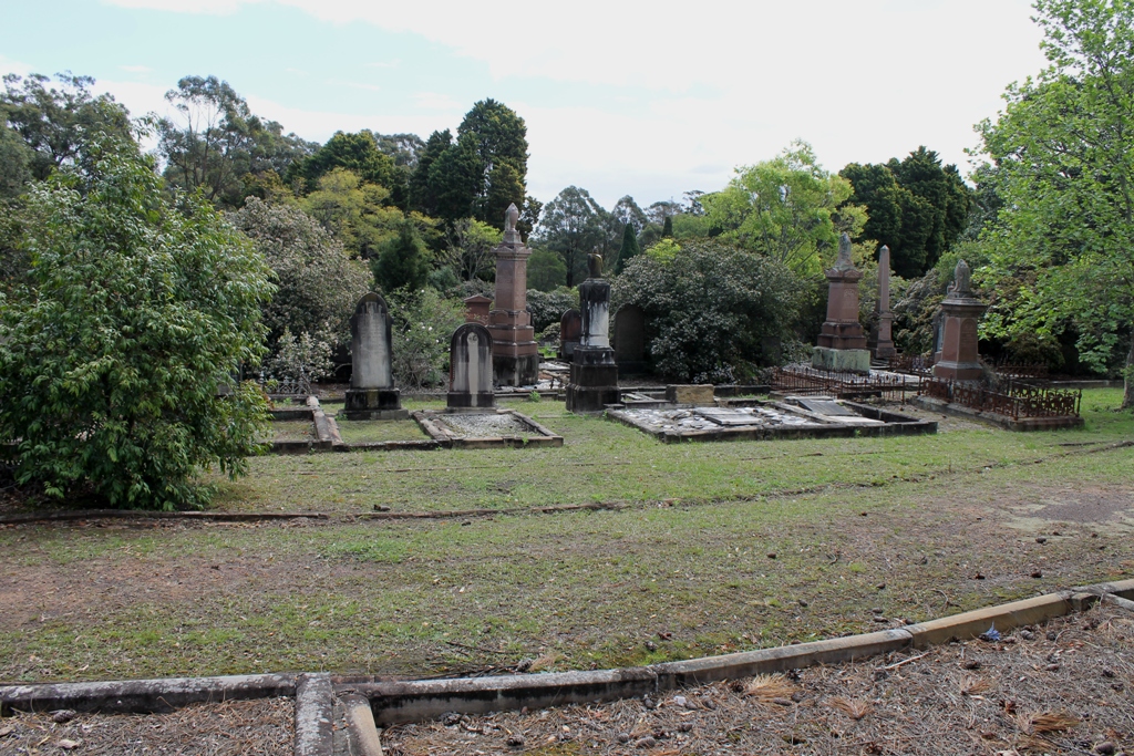
[Photo taken facing west-south-west. Clergy Section in the foreground. Section 1D Circle is in the distance to the left behind the trees.]
SECTION 1A.

[Photo taken facing west-north west. Start of Section 1B Perimeter on the far right.]
SECTION 1B.

[Photo taken facing north-north-west, with the top of Section 1A Circle on the left behind the foliage.]
SECTION 1C.

[Photo taken facing almost due south, with the Section 1D Circle on the right, behind the foliage.]
SECTION 1D.
[Photo taken facing almost due west, over the edge of Section 1C Perimeter in the foreground.]

[Same location, facing north-west, and a little closer than above.]

[Same location, facing north-west, and a little closer than above.]
SECTIONS 2A AND 2B.

[The "Friends of Rookwood" Memorial Rose Garden. The large Section 2A and 2B Circle is in the distance, across the intervening grassed pathway.]


Above - Southern end of Row 1 (east) of the large 2 circle, showing about six plots comprising Section 2C in-fill, with one of the first older plots in Section 2A on the far right.
Below - Detail of the drainage sump in the centre of the above photo, showing the corner of the southern-most infill plot, with the drainage sump, at the start of the continuing original brick gutter heading off to the left down-hill. This part may be original, and probably very close to where the pointy end of the original section 2B commenced.

However, it would seem that this sump may not have been part of the original layout - as both parts of the pointy end would have led downhill., away from that point, rendering a sump as being superfluous.

[Aftermath of storm damage in early February 2020 - a fallen large conifer tree in the Section 2 Circle 2C infill, partially removed.
Photo taken facing south-west with Section 2D Triangle in the middle distance]

[Another tree felled in the storm in Section 2 Circle, 2B, south side, with most of the debris cleaned up, and the tilted stump remaining stood back up to near vertical. Photo taken facing north east.]
- - - - - - - - - - - - - - - - - - - - - - - - - - - - - - - - - - - - - - - - - -

Above - The diametrically opposite part of the big 2 Circle, on the north western side, showing the rear of one of the Section 2C in-fill plots in the second last row (west), looking towards the north east along the exit point of the original serpentine pathway that separated sections 2A and 2B. The brick gutter to the lower right marks the former boundary of Section 2B.
Below - Detail of the vertical drain (with silt trap), connecting the circular section 2A brick gutter to the underground pipework, on the left side of the above photo, marking the pointy western end of the original Section 2A tear-drop. Clear evidence, in the form of the single remaining brick, of the other tail heading off to the right of the outer 2A circle gutter (heading to the top of the photo):

SECTION 2C.

[Section 2C Triangle. Photo taken pointing due north.]
SECTION 2D, South Perimeter.
[Pics to come]
SECTION 2D Triangle.

[Section 2D Triangle, Eastern point. Photo taken pointing almost due west.]

[Ditto, Western point - photo taken pointing due east.]
SECTION 2E.

[Photo taken facing due south, towards the Old Presbyterian Portion, across the bitumen road.]

[Western most point. Photo taken facing due east, after cleaning of gutters.]

[Western most point. Photo taken facing due east, after cleaning of gutters.]
Section 2E Triangle, south between the 2A/2B and the 3A Circles, comprising 42 Plots in 4 Rows, numbered Odds (facing north) and Evens (facing south) from west to east, commencing from the south:
Row 1 - Plots 2-30.
Row 2 - Plots 3- 27.
Row 3 - Plots 32-42.
Row 4 - Plots 33-41.
SECTION 3A.

[Photo taken facing west-south-west, with the elongated most easterly part of the "tail" in the centre, and part of the Section 3B North Perimeter to the right.]

[Photo closer to the same point as above, after cleaning of gutters.]

[Photo taken from near Section 2E, and pointing west-north-west.]
SECTION 3B.
Section 3B on the south side of the 3A Circle. Plots 1-64 at the south end of Rows 1 through to 19 (but numbering from the west, and Odds and Evens):
...
Row 16 - Plots 41 to 45 (BURROWS).
Row 17 - Plots 40 to 44 (ADAMS).
Row 18 - Plots 309 (RAINY) to 311 (CLAYTON).
Row 20 - Plots 45 to 54, including 50 (COOPER) and 52 (PEARCE).
Section 3B North Perimeter. Commencing opposite the last Row of the 2A/2B Circle, and numbered linearly, at Plot 78 (PARKER), through to Plot 163 (CHURCHILL).

[South Perimeter, western most point, looking due east.]
Section 3B South Perimeter. Commencing two unmarked plots east of Section 4C South Perimeter BARNETT - see below), and heading east up the hill, numbered linearly but in disordered blocks. Commencing at Plot 164 (RUSSELL) through to Plot 189 (no gravestone); jumping forward to Plot 273 (WEBSTER) through to Plot 285 (GROVES); jumping back to Plot 235 (WHITE) through to 247 (ORR); jumping further back to Plot 190 (RITCHIE) through to Plot 234 (ORR).

[The 3B Triangle, eastern most point. Photo taken facing west by north-west.]

[Ditto. Photo taken facing east-north-east, towards the 3 Circle in the distance, with several rows of 3B Circle plots immediately across the intervening pathway.]
Section 3B Triangle, with 20 Plots in 3 Rows, numbered Odds and Evens, commencing in the south, from west to east:
Row 1 - Plots 252 (BOWTELL - nearest plot in photo above) to 268 (ROBINSON) .
Row 2 - Plots 259 (BOXSELL) to 265 (BROWN).
Roe 3 - Plots 269 (GUINERY plot on the left in photo) to 272 (no gravestone).
SECTION 3C.
[Pic to come]
North Perimeter section, commencing opposite the path between Rows 3 and 4 in Section 4 Circle. Plots number linearly from Plot 1 (OLDS family double) west towards the entrance gate, curving around to the Western Perimeter, and ending at Plot 133 (HARMER Plot), about the middle of the Western Perimeter (which backs onto the hedge and curved wall at the roadway entrance from East Street), two vacant plots north of the commencement of Section 4C Western Perimeter (see below).
SECTION 3D.

[Photo taken looking north, showing the westernmost and last row in the foreground.]
Section 3D Triangle, north west of the 4A Circle, containing 132 Plots in 9 Rows, numbered odds and evens, commencing at the most eastern point:
Row 1 - Plots 1 to 5 facing east, including Plot 3 (McANULTY).
Row 2 - Plots 2 (JONES) to 10 (HANSELL) facing west.
Row 3 - Plots 11 (BANNING) to 29 (EDWARDS).
Row 4 - Plots 12 to 32, including Plots 14-16 (CANNING) and 26-30 (STANTON and MATTERS).
Row 5 - Plots 33 to 63 (MASON), including Plot 35 (GARLAND).
Row 6 - Plots 34 (WASSALL) to 64 (BOWD).
Row 7 - Plots 67 (TOOTING) to 109 (no gravestone), including Plots 103-105 (KNIGHT).
Row 8 - Plots 62A (MORRIS) to 107 (no gravestone), including Plot 98 (COLLINS).
Row 9 - Plots 110 (D.A.W.) to 132 (SWANSON).
SECTION 4A.

[Photo taken facing north-west, showing the south-eastern edge.]
Section 4A, inside the 4 Circle in two halves, numbered linearly (higher numbers) and Odds and Evens (lower numbers), in successive rows from east to west, the plots numbering from south to north in each row (mostly - and certainly for the odds and evens):
Row 1 - Plots 2260-2262 and 2268-2271, facing east, numbering linearly.
Row 2 - Plots 2272-2273 (linear); Plots 1237-1291 (odds); all also facing east, and north of the Section 4C Plots.
Row 3 - Plots 2274-2276 (linear); Plots 1238-1286 (evens) facing west; all north of the Section 4C Plots.
Row 4 - Plots 1701-1715 (odds) facing east; [Section 4C Plots intervene here]; Plot 2277 (*); Plots 1293-1375 (odds); Plots 2253, 2254 (linear, at north end of row).
Row 5 - Plots 2322-2323 (linear); Plots 1708-1716 all evens [Section 4C Plots intervene]; Plots 2278,2279 (*); Plots 1294-1374 all evens; Plots 2250-2252 (linear, at north end of row).
Row 6 - Plot 2324; Plots 1717-1733 (odds); [Section 4C Plots intervene]; Plots 2280-2281(*); Plots 1375-1465 (odds); Plots 2248-2249 at north end of row).
Row 7 - Plots 2325-2326; Plots 1718-1734 (evens); [Section 4C Plots intervene]; Plots 2282,2283 (*); Plots 1376-1466 (evens); Plots 2246, 2247 and 2301 (linear, north end of row).
Row 8 - Plot 2327; Plots 1735-1759 (odds); [Section 4C Plots intervene]; Plots 2284, 2285 (*); Plots 1469-1557 (odds); Plots 2244, 2245 (linear, north end of row).
Row 9 - Plots 2328, 2329; Plots 1736-1760 (evens); [Section 4C Plots intervene]; Plots 2321, 2286; Plots 1468-1558 (evens); Plots 2241-2243 (linear, north end of row).
Row 10 - Plot 2330; Plots 1763-1799 (odds); Plots 2287-2290 (linear - possibly instead north of 4C Plots?); [Section 4C Plots intervene]; Plots 2189-2200 (linear) (*); Plots 1559-1613 (odds); Plots 2339, 2340 (linear, north end of row).
Row 11 - Plot 2331; Plots 1762-1798 (evens); Plots 2319, 2320 (linear); [Section 4C Plots intervene]; Plots 2391-2393 (linear) (*); Plots 1560-1614 (evens); Plots 2237, 2238 (linear, north end of row).
Row 12 - Plot 2331; Plots 1799-1853 (odds); [Section 4C Plots intervene]; Plots 2294, 2295 (*); Plots 1615-1651; Plots 2235, 2336 (linear , north end of row).
Row 13 - Plot 2333; Plots 1800-1854 (evens); Plots 2177-2187 (linear north to south); [Section 4C Plots intervene]; Plots 2316-2318 (linear) (*); Plots 1616-1654 (evens); Plots 2333A and 2334 (north end of row).
Row 14 - Plot 2335; Plots 1855-1945 (odds); Plot 2315; [Section 4C Plots intervene]; Plot 2396 (*); Plots 1653-1677; Plots 2232, 2330, 2331 (north end of row).
Row 15 - Plot 2336; Plots 1856-1946 (evens); Plots 2312-2314 (linear); [Section 4C Plots intervene]; Plots 1654-1678 (evens); Plots 2228, 2229 (north end of row).
Row 16 - Plots 2337, 2338; Plots 1947-2037 (odds); Plots 2309, 2310, 2311; [Section 4C Plots intervene]; Plots 1679-1695 (odds); Plots 2226, 2227 (north end of row).
Row 17 - Plot 2239; Plots 1948-2038 (evens); Plots 2306, 2307, 2308; [Section 4C Plots intervene]; Plots 1680-1696 (evens); Plots 2244, 2245 (north end of row).
Row 18 - Plots 2340, 2341; Plots 2039-2119 (odds); [Section 4C Plots intervene]; Plots 1697-1705 (odds); Plot 2228 (north end of row).
Row 19 - Plots 2040-2120 (evens); Plots 2302, 2303; [Section 4C Plots intervene]; Plots 1698-1706.
Row 20 - Plots 2342-2345 (linear, north to south); Plots 2121-2175 (odds); Plots 2298, 2299, 2300 (north to south); [Section 4C Plots conclude].
Row 21- Plots 2122-2176 (evens); [Section 4C Plots intervene]; Plot 2297.
Row 22 - Plots 2201-2203 (odds); Plots 2204-2222 (linear).
Plots above marked (*) - it is impossible to now determine on the ground, and not entirely clear from the S.A.G. Transcription, whether these "additional" plots are north or south of the intervening 4C Plots - I have made the tentative judgment that they are all north, but I may be wrong.
It looks to me like the original serpentine pathway was "infilled" with 4C plots, even before the new cemetery extension was occupied after the 1880s, and that more additional spaces were filled and given the higher 4A linear numbers later again.
SECTION 4B.

[Photo taken looking due west, with the curve of the south boundary of the Section 4A Circle on the right.]
Section 4B Triangle (south west corner, between Perimeter 4C and the 4 Circle):
185 Plots in 11 Rows, numbered odds and evens, commencing at the eastern corner, and concluding on the north west corner.
SECTION 4C.
Section 4C comprises two parts - a part of the outer perimeter row, and then the "infill" double "S" pathway that meanders through the middle of section 4A.
The plots are numbered linearly throughout (as opposed to the Odds-and-Evens method used in Section 4A). They begin numbering from about the middle of the western-most perimeter row which backs onto the vehicular entrance from East Street, Lidcombe. Plot 1 is the grave of Catherine Nicholson LONG. The graves initially face east, and number southwards, then curving around into the perimeter row on Cohen Street where they face north. The last plot in that perimeter is plot 131 (which has no gravestone), ten grassy plots up the hill and east of plot 121 (Henry WALTON).
The next five plots face east, in the southern end of Row 2 of the Section 4A circle - plots 132-133 (FRIPP family members); one grassy plot north of them is plot 135 (Charles PURKISS); then plot 136 (Emma BIRD and Emma FOULKES). The rest of that row are Section 4A plots.
Section 4C West and South Perimeters; commencing in the middle of the West Perimeter, numbered linearly to the south; Plots 1-51, all facing due east; continuing around the south-west corner with plots 52-60; and up the South Perimeter to the east, Plots 61-130 facing approximately north (ending opposite the path between Rows 3 and 4 in the 4 Circle).
Section 4C serpentine inside the 4 Circle, numbered linearly and alternately back and forward - Plots 132-136 in Row 2 (from south-to north, including FRIPP, PURKISS, BIRD and FOULKES); Plots 137-144 in Row 3 (north-south, including BROWN, AUSTIN, PINKERTON and AULD); Plots 145-149 in Row 4 (s-n, including Skinner and CROOK); Plots 150-153 in Row 5 (n-s, including MUMBY and HALL); Plots 154-157 in Row 6 (etc, including JOHNSON and CAMPBELL); Plots 158-161 in Row 7 (all grass); Plots 161-167 in Row 8 (including KEY); Plots 168-172 in Row 9 (including ARGALL); Plots 174-181 in Row 10 (including PHILPOTT, WILLIAMS and FRESHWATER); Plots 182-201 in Row 11 (including WALKER, ALESSIO, BURNS, PARSONS, ALLEN and MASLIN); Plots 202-223 in Row 12 (including BANNING, BRAY and WRIGHT); Plots 224-233 in Row 13 (including ROGERS and OUGHTON); Plots 234-239 in Row 14 (including BYGRAVE); Plots 240-244 in Row 15 (n-s, including HARDGREAVES); Plots 245-247 in Row 16 (including MAINWARING); Plots 248-250 in Row 17 (including SYMONS); Plots 251-254 in Row 18 (including HELLYER); Plots 255-258 in Row 19 (including ROBSON); Plots 259-266 in Row 20 (including SPARKS, JONES and WRIGHT); and Plots 267-271 in Row 21 (including COOKE, ELDRIDGE, GOLDEN, and HELLMERS).
SECTION 4D.
Section 4D Triangle (north, between the 3 and 4 Circles):
29 Plots in 3 Rows numbered linearly from the north-east corner: Plots 1-14 facing north; Plots 15-23 facing south-west; and Plots 24-29 facing south-east.
________________________________________________________________________________
A PERSONAL CONNECTION.
The Illustrated Sydney News, published on Monday 20 April 1868, reported the following:
"THE NECROPOLIS.
"The New South Wales Government Gazette thus defines the boundaries and extent of the land set apart for the use of the various denominations, and gives the names of the various trustees:-
"Church of England: 53 Acres 3 Roods; Trustees Messrs M.E. MURNIN, J. DAWSON, W. DAY, G.E. CRANE, and S.H. PEARCE.
"Roman Catholic: 39 Acres; Trustees the most Reverend J.B. POLDING, Rev S.J.A. SHEEHY, and Messrs T. Makinson, G. PHILLIPS, and M. McMAHON.
"Presbyterian: 11 Acres 1 Rood; Trustees the Hon S.D. GORDON, Messrs BROWN, FRAZER, GOODLET and MOODIE.
"Wesleyan: 6 Acres 1 Rood; Trustees Messrs CALDWELL, COWLISHAW, WEARNE, VICKERY, BAILEY and GOLLEDGE.
"Independent: 5 Acres; Trustees Messrs S. THOMPSON, FAIRFAX; JONES, MULLEN, ROLIN and ILLIDGE.
"Jews: 2 Acres 1 Rood; Trustees Messrs COHEN, JOSEPH, SAMUELS, ALEXANDER and PHILLIPS.
"The General Cemetery: 58 Acre; Trustess Messrs G. THORNTON, T. SPENCE, J. SUTHERLAND, J. MURPHY and J. WOODS."
It would appear highly likely that T. SPENCE, the second listed Trustee of the General Cemetery, was my great-great-grandfather Thomas SPENCE, Builder, of Wooloomooloo.
* * * THIS IS A WORK IN PROGRESS * * *
UNTIL THIS NOTICE IS REMOVED, ADDITIONS AND ALTERATIONS WILL CONTINUE TO BE MADE.

No comments:
Post a Comment